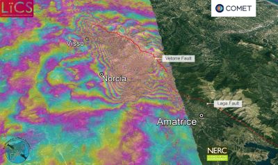
BBC Science —  There remains the potential for future quakes in Italy’s Apennines region, say scientists who have reviewed the latest satellite maps of the region. The new radar imagery suggests Sunday’s big tremor ruptured a segment of a fault in between sections broken by two other quakes in recent weeks. But the Magnitude 6.6 event has still left the deeper parts of the fault system locked in place. And this unrelieved stress now represents a risk down the line.
The researchers are keen to emphasise, however, that predicting precisely when and where a future quake might strike is not possible. No-one was killed in Sunday’s big tremor but more than 30,000 residents have been left homeless as a consequence of the damage it wrought. The new space data comes from Europe’s Sentinel-1 satellites which overfly Italy every day or so. These platforms are able to sense ground movement by comparing before and after radar imagery acquired from orbit.
The scientists turn this information into an interferogram – a colourful, but highly technical, depiction of the displacement that occurs on a fault.